


Share This Article
Article Summary:
The federal government has awarded Hamilton County $25 million toward capping a section of Fort Washington Way. The funding is new. The groundwork that made it possible isn’t — and that backstory is what makes this project different from a standard infrastructure announcement.
Stand on Third Street and look toward The Banks.
Between downtown and the river sits an eight-lane trench carrying Interstate 71 traffic through the center of Cincinnati.
For decades, planners imagined covering part of that gap with parks, plazas, and new public space. This week, that vision moved closer to reality. The U.S. Department of Transportation awarded Hamilton County a $25 million BUILD Program grant to begin design and construction of the first phase of the Fort Washington Way cap project.
The federal funding is new. The groundwork that made it possible isn’t. Long before Hamilton County secured this week’s grant, engineers rebuilding Fort Washington Way made a decision that shaped today’s project.
Fort Washington Way: A Decision Engineers Made During Reconstruction
When Fort Washington Way underwent its massive reconstruction between 1998 and 2000, engineers faced a problem. The project was already underway when community interest in capping the highway began to grow. It was too late to change the design entirely. So engineers made a compromise.
Instead of capping the highway, they drove 750 support piles deep into the ground — engineered specifically to hold future decks above the roadway. The pile driving cost $10 million and took place between February and August of 2000. Engineers noted at the time that doing the work during reconstruction saved an estimated $14 million compared to doing it later.
The foundations were designed to support either a park-style green space or low-rise structures up to four stories tall, spanning roughly 600 feet over the highway between Elm Street and Main Street. In other words, city leaders and engineers in the late 1990s spent $10 million on infrastructure for a project they couldn’t yet afford — and that wouldn’t be funded for another 25 years.
“WSP had a great team with the foresight to plan and build the infrastructure into the original project to allow for the development of these decks now,” said Jared Love, assistant vice president at WSP, one of the engineering firms involved in both the original reconstruction and the current cap design.
Without those support piles, today’s project would require a far more expensive reconstruction before a cap could even be considered.
| Year | Milestone |
|---|---|
| 1998–2000 | Highway reconstruction Fort Washington Way rebuilt with a narrower footprint, freeing land for The Banks and two new stadiums. |
| 2000 | 750 support piles installed $10 million investment during reconstruction; saved an estimated $14 million compared to doing it later. |
| 2000–2025 | No funding secured Three federal grant applications submitted and unsuccessful. |
| July 2026 | $25M federal BUILD grant awarded Fourth attempt succeeds. Covers planning, design, and first construction phase. |
| Next phase | Design and first construction begins 1.2-acre cap between Vine and Walnut streets. Approximately $162 million still to be funded. |
| Future | Potential expansion Full riverfront redesign estimated to take 10–15 years to complete. |
What the Fort Washington Way Cap Will Actually Build
The $25 million grant funds the first phase of a larger project. Specifically, it covers planning, design, advanced engineering, and initial construction of a cap over a one-block section of I-71 between Walnut Street and Vine Street.
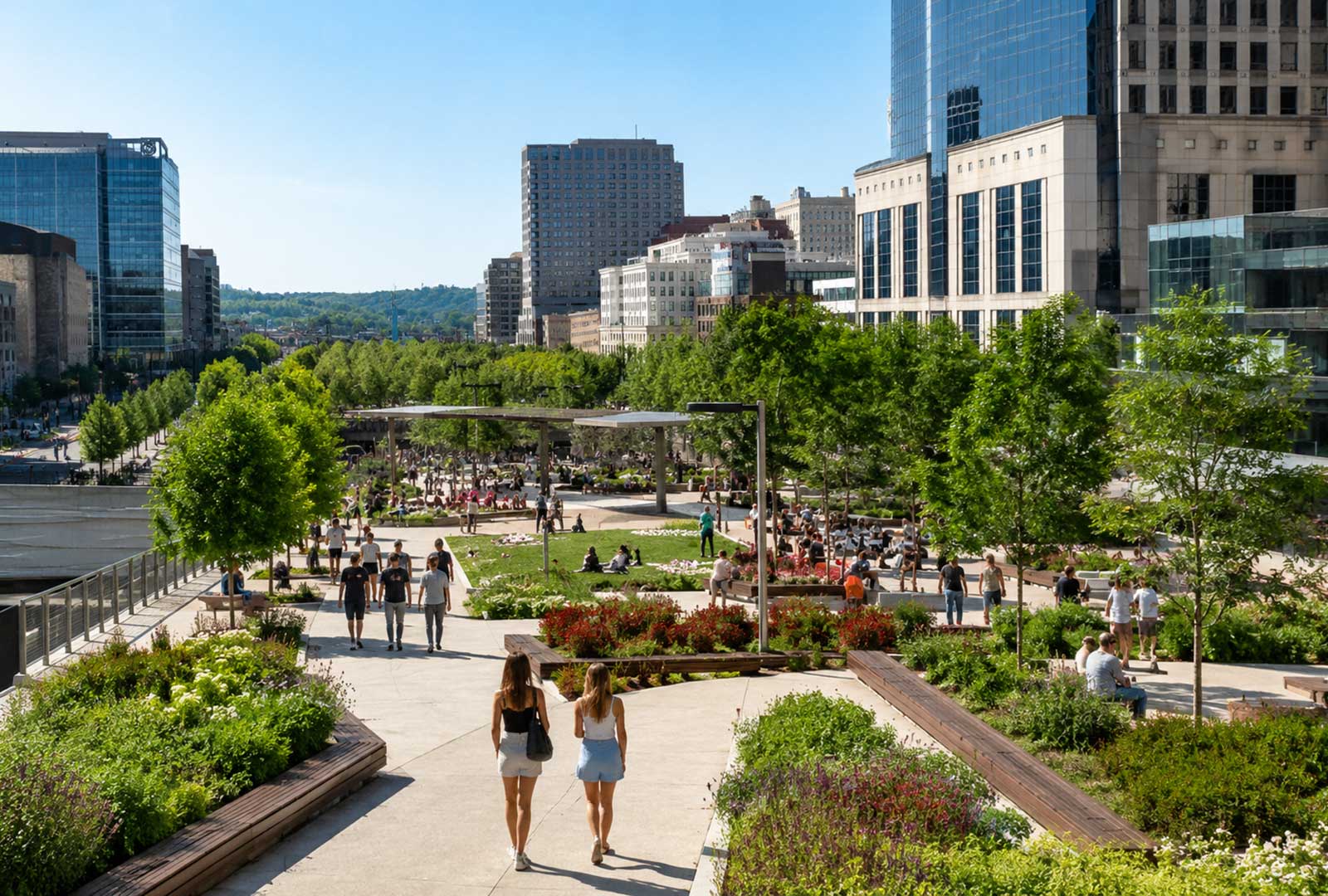
That section will create a 1.2-acre highway cap and public plaza between Second and Third streets. The goal is to reconnect the Central Business District with The Banks neighborhood, which has been physically separated from downtown by the sunken highway trench for decades.
“This federal funding opportunity represents a once-in-a-generation chance to reconnect our downtown, create new public green space, and continue the momentum at The Banks,” said Hamilton County Commission President Stephanie Summerow Dumas.
Additionally, this marks the fourth time Hamilton County applied for federal funding for the project. The previous three attempts were unsuccessful. As a result, this award carries additional significance beyond the dollar amount.
Cincinnati Isn’t Just Building a Park
Most coverage frames this project as a green space initiative. That framing is accurate, but incomplete.
Every acre of downtown Cincinnati already belongs to someone. Building over Fort Washington Way creates 1.2 acres of usable urban land without demolishing a single building. That land can support parks, development, or both — and it sits at the intersection of the Central Business District and the riverfront, arguably the most valuable corridor in the region. In a city where housing supply continues to lag behind demand, new developable land in the urban core carries real long-term value.
Cincinnati’s version of that story began in the 1990s, when engineers made a $10 million bet that future generations would want this option. Other cities have since demonstrated what that kind of urban land can unlock. Dallas built Klyde Warren Park over the Woodall Rodgers Freeway, and the surrounding blocks saw significant new development in the years that followed. Boston’s Rose Kennedy Greenway replaced the elevated Central Artery and similarly catalyzed activity along its edges. In each case, the park was the visible result. The new land beneath it was the long-term asset.
Therefore, supporters of the Fort Washington Way cap argue the investment is not just about green space. It is about creating developable urban land in a location that currently produces none.
“It could be a place where citizens from all over this region come to play, come for events, come to celebrate together,” said Tim Sharp, chief strategic officer at KZF Design, another firm involved in both the original reconstruction and the cap’s design.
The Cost Question Is Real
Nevertheless, the project’s price tag demands attention.
The total estimated cost of the Fort Washington Way cap has grown to approximately $187 million. The new federal grant covers about 13 percent of that figure. The remaining funding will have to come from future federal grants, state dollars, local contributions, private investment, or some combination of all four. For context on how large infrastructure investments play out locally, our reporting on Cincinnati’s broader economic pressures is worth reading alongside this announcement.
Supporters argue the investment will generate new development activity and long-term property tax revenue around the cap. That debate will continue well beyond this week’s announcement.
What Fort Washington Way Means for Greater Cincinnati
The Fort Washington Way cap project fits into a broader national trend of cities revisiting the urban highways built in the mid-20th century. Across the country, from Boston to Dallas to San Antonio, communities are capping, removing, or redesigning highway infrastructure that once severed neighborhoods from each other and from waterfronts. The U.S. DOT BUILD Program, which funded this grant, was created specifically to support projects of this kind.
For Greater Cincinnati, the implications extend beyond a new park. A successful cap could strengthen The Banks, add new development land in the urban core, and restore a pedestrian connection between downtown and the riverfront that has been missing for more than half a century. Those outcomes matter even more as Greater Cincinnati’s population continues to grow and competition for urban space increases.
The concrete has been waiting underground since 2000. Twenty-five years later, Cincinnati finally has the money to begin building what those engineers planned for decades ago.
FAQs
What is the Fort Washington Way cap project?
The project proposes building a deck over a section of Interstate 71 in downtown Cincinnati, between Vine and Walnut streets. The cap would create a 1.2-acre public plaza and green space, reconnecting the Central Business District with The Banks neighborhood along the riverfront.
How much does the project cost?
The total estimated cost is approximately $187 million. The new federal BUILD Program grant covers $25 million — about 13 percent of that total. Additional funding will be needed to complete the full project.
Why is the project possible now?
During the original reconstruction of Fort Washington Way between 1998 and 2000, engineers drove 750 support piles into the ground at a cost of $10 million. Those foundations were specifically designed to support future decks above the highway. Without that investment, the cap project would be significantly more expensive and complex today.
When will construction begin?
The $25 million grant funds design, planning, and initial construction of the first phase. A full construction timeline has not been announced.
Has this type of project worked in other cities?
Yes. Similar highway cap projects have been completed in Dallas (Klyde Warren Park), Boston (Rose Kennedy Greenway), San Antonio, Phoenix, and other cities. Each project varies in scope and cost, and outcomes have differed across locations.
This article is for informational purposes only. Project costs, timelines, and funding details are subject to change. The Cincinnati Exchange recommends consulting official sources for the most current project information.
