


Share This Article
Article Summary
Cincinnati faces escalating flood risks driven by climate change, rapid urbanization, and a distinct valley ridge topography that rapidly channels heavy rainfall into low-lying areas. Historic storms have repeatedly overwhelmed the city’s aging drainage systems and exposed structural vulnerabilities in critical water infrastructure. In response, local officials are executing the Green Cincinnati Plan to upgrade municipal water governance using predictive machine learning models and nature-based green infrastructure. Evaluating both direct and indirect economic losses from these urban floods is currently helping the city secure necessary funding for long-term resilience projects.
As extreme weather events increase, assessing the flood risk in Cincinnati has become a top priority for local leaders.
Understanding the true Cincinnati flood risk requires examining both historical data and future climate projections.
Residents express increasing concern about local flooding as heavy rains frequently overwhelm neighborhood drainage systems. Recent studies highlight how climate change directly impacts this Cincinnati flood risk across numerous communities. City officials are aggressively updating disaster preparedness strategies to protect residents. These vital updates aim to address the highly complex nature of urban flooding. The city faces a unique combination of riverine flooding and rapid urban runoff. Consequently, regional planners work tirelessly to secure vulnerable water infrastructure.
ALSO READ: Flood risk rises as heavy rain threatens Greater Cincinnati through midweek
How topography and urbanization impact Cincinnati flood risk
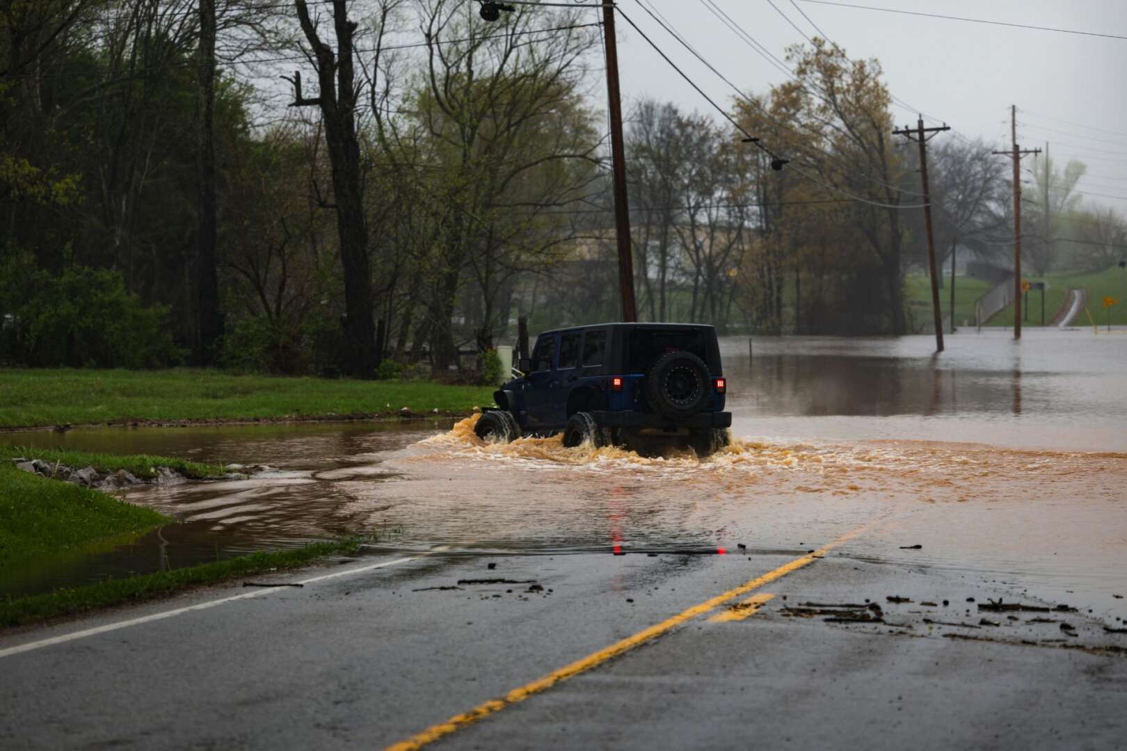
Cincinnati features a distinct valley ridge topography that greatly complicates municipal water management. The city sits on the north bank of the Ohio River at an average elevation of 224 meters. This varied, hilly terrain rapidly directs heavy runoff toward lower areas like Mill Creek. As a result, surface water accumulates dangerously fast during intense rainfall events. Researchers note that this specific topography makes urban pluvial flooding a frequent and severe hazard. Pluvial flooding occurs when extreme precipitation simply exceeds the local drainage capacity.
Urbanization further aggravates this challenging environmental situation. As the city expands, developers replace natural vegetation with impervious surfaces like concrete and asphalt. These hard surfaces actively prevent stormwater from naturally infiltrating the soil. Instead, the excess water rushes directly into already strained municipal sewer systems. Studies confirm that combining rapid urbanization with climate change significantly amplifies global flood risks. For Cincinnati, this dangerous combination means flash floods can strike neighborhoods with almost no warning.
Historic storms reveal vulnerable infrastructure
Cincinnati has a well-documented history of devastating pluvial floods that disrupt daily life. A particularly notable event occurred in August 2016. A once-in-a-century storm dumped approximately 101 millimeters of rain in just two and a half hours. This massive, sudden deluge caused widespread inundation across several vulnerable communities. Neighborhoods like St. Bernard, Norwood, Paddock Hills, and North Avondale suffered severe property damage. Emergency responders scrambled immediately to assist residents trapped by the rapidly rising waters.
This historic event fully exposed the limitations of the city’s aging, mixed drainage infrastructure. The community continuously deals with combined sewer overflows and hazardous riverine flooding. Protecting critical dams, levees, and flood pump stations remains a massive regional challenge for local authorities. Furthermore, past officials frequently built older wastewater treatment plants in low-lying, flood-prone areas. These critical facilities face extremely high exposure to rapid peak flows under flash flood conditions.
The role of the Green Cincinnati Plan
City leaders rely heavily on comprehensive strategies to build long-term regional resilience. The Green Cincinnati Plan outlines specific, actionable steps to mitigate the worsening effects of climate change. A major focus involves completely upgrading the municipal water governance framework. Interstate and regional collaboration is absolutely essential given the city’s close proximity to the Kentucky border. Officials regularly coordinate with neighboring jurisdictions to manage the expansive Ohio River basin effectively.
The Green Cincinnati Plan strongly emphasizes sustainable, nature-based adaptation measures. Investing in green infrastructure actively helps absorb excess rainwater before it ever reaches the sewers. City planners increasingly install rain gardens, permeable pavements, and bioswales across various districts. These nature-based solutions drastically reduce the daily burden on traditional underground pipe networks. They also significantly improve local water quality by filtering harmful pollutants from street runoff. Community engagement plays a vital role in executing these environmental projects successfully.
Climate preparedness and adapting to Cincinnati flood risk
Modern climate preparedness requires highly innovative planning and advanced technological solutions. Local governments must identify infrastructure projects that actively reduce future environmental vulnerabilities. Scientists currently use sophisticated machine learning models to accurately predict urban pluvial flood susceptibility. These powerful models combine historical storm event records with real-time crowdsourced data. By doing so, they provide a much clearer picture of localized flooding dynamics. This data-driven approach helps urban planners prioritize infrastructure upgrades effectively and efficiently.
Adaptation strategies also involve direct community intervention and robust public education. Officials actively explore ways to relocate vulnerable electrical and water equipment out of designated flood zones. Upgrading emergency alert systems ensures residents receive timely warnings during severe, life-threatening storms. Furthermore, educating the public about personal flood preparedness remains a top administrative priority. Federal Emergency Management Agency data indicates many households still lack adequate flood insurance. Better communication strategies strongly encourage residents to take proactive safety measures.
Many community organizations actively assist in these ongoing municipal preparedness efforts. Neighborhood councils host regular community meetings to discuss emergency evacuation routes. They also distribute readiness kits containing essential supplies for unexpected power outages. This grassroots involvement forms a critical cornerstone of the city’s overall safety strategy. Empowering residents with knowledge and resources drastically reduces the potential for injury during disasters.
Measuring the economic toll of urban flooding
Urban flooding causes massive economic disruptions that extend far beyond immediate property damage. Assessing the true cost requires accurately evaluating both direct and indirect financial losses. When local businesses flood, they cannot operate at full capacity for days or even weeks. This sudden business interruption ripples through the regional economy, negatively affecting jobs and supply chains. Researchers clearly emphasize that ignoring these indirect losses severely underestimates the benefits of flood mitigation.
Local leaders now utilize specialized economic models to calculate these socioeconomic impacts accurately. For example, specific hazard methodologies help assess direct financial impacts on commercial structures. Understanding potential flood depths allows building officials to estimate how long properties will remain unusable. This comprehensive economic data is crucial when cities apply for competitive federal infrastructure grants. It definitively proves that investing in robust drainage systems saves the regional economy millions of dollars. The Cincinnati Exchange previously reported on local business resilience in the face of these environmental pressures.
Future outlook for Ohio flood zones
The future safety of Ohio flood zones depends heavily on immediate and sustained climate action. Climate change will likely increase the frequency and severity of extreme weather events locally. Experts warn that structural stress on sanitation systems and local facilities will only intensify. Downscaled climate projections suggest a dangerous concentration of precipitation into more extreme, shorter bursts. Consequently, Cincinnati must prepare for much larger volumes of water hitting the ground faster. Long-term projections indicate systematic increases in hazard extent and devastating economic damage.
To successfully combat this, the city must continually update its municipal resilience frameworks. Evaluating the socioeconomic impacts of flooding is critical for securing ongoing federal and state support. Planners carefully review recent updates on Ohio infrastructure projects to align local efforts. Understanding these indirect economic losses easily justifies much larger investments in urban flood protection. By remaining proactive, Cincinnati can build a significantly safer environment for future generations. Local news outlets will continue to monitor these critical ongoing climate resilience efforts closely.
References
Ahmed, F. (n.d.). Improved understanding of tropical urban catchment hydrology by SWMM modeling and sensitivity analysis: a case study of Udon Thani City, Thailand. IWA Publishing.
Flor Tey, G. (n.d.). Climate Change Effects on Flood Risk at Wastewater Treatment Plants: A Facility-Scale Assessment. MDPI.
Parent, O., Hofe, R. v., Oh, S., Ervin, P., Khalid, M. A., & Yeghiazarian, L. (2023). Estimating the Socioeconomic Impacts of Flooding on Regional Economies With a Computable General Equilibrium Model. Water Resources Research, 59. https://doi.org/10.1029/2022wr033474
Raub, K. B., Laufer, J., Flynn, S. E., Daniels, S., & Sivalingam, T. (2024). Harnessing climate services to support community resilience planning: lessons learned from a community-engaged approach to assessing NOAA’s National Water Model. Frontiers in Climate, 6. https://doi.org/10.3389/fclim.2024.1291165
Salau, O. (n.d.). Modelling Urban Pluvial Flooding in Cincinnati, Ohio, Using Machine Learning. MDPI.
FAQs
Why is Cincinnati particularly vulnerable to flooding?
Cincinnati sits in a hilly valley ridge topography along the Ohio River, which directs heavy rainfall rapidly into lower elevations like Mill Creek. Combined with expanding urbanization and impervious surfaces, this terrain causes surface water to accumulate dangerously fast during intense storms.
What is pluvial flooding?
Pluvial flooding happens when extreme precipitation simply exceeds the capacity of local municipal drainage systems, causing water to pool on the surface. In Cincinnati, this phenomenon frequently leads to sudden flash floods in neighborhoods with high concentrations of concrete and asphalt.
How does the Green Cincinnati Plan address these flood risks?
The plan strongly emphasizes nature-based adaptation measures, such as installing rain gardens, permeable pavements, and bioswales to absorb excess rainwater before it enters sewers. These green infrastructure projects directly reduce the burden on traditional underground pipe networks while filtering harmful pollutants from street runoff.
Why is measuring the indirect economic costs of flooding important?
Urban flooding causes severe business interruptions that negatively impact regional supply chains, total industry output, and jobs. Accurately modeling these indirect financial losses proves the cost-effectiveness of robust drainage systems and helps the city justify and secure competitive federal infrastructure grants.
