


Share This Article
Ohioans can now look up redistricting of their newly assigned congressional, statehouse, and state senate districts with a street-level interactive map created by the Ohio Secretary of State’s Office.
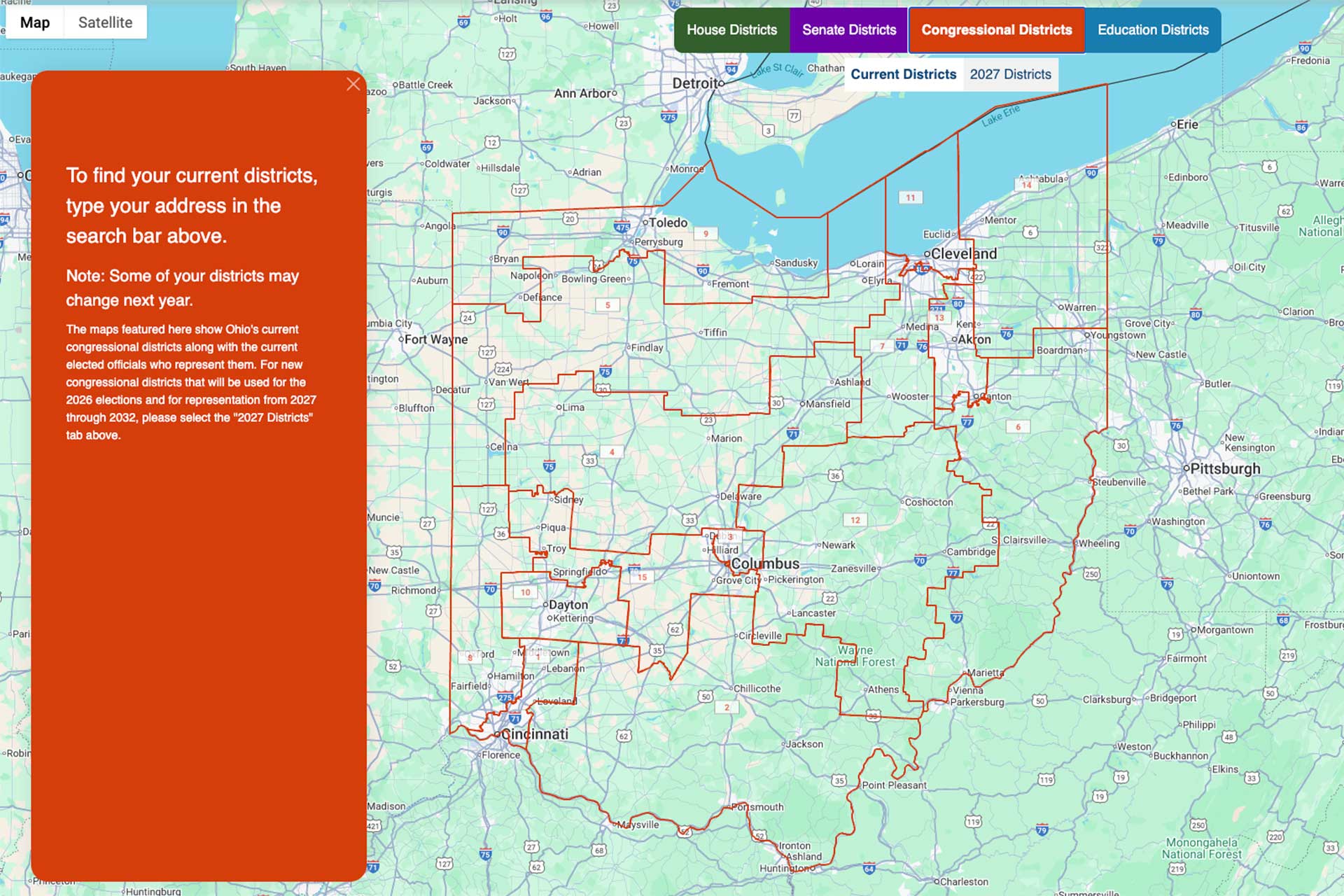
The redistricting tool — unveiled this week by Secretary Frank LaRose — allows residents to search by address and instantly see which districts they fall into following Ohio’s latest redistricting overhaul.
The site for redistricting is live now at findmydistrict.ohiosos.gov.
LaRose told The Cincinnati Exchange that the tool was built to eliminate confusion as the 2026 election cycle begins to ramp up.
“My team created an interactive map with the new district lines that you can search by address and zoom in down to the street level,” LaRose said.
With Ohio’s maps redrawn, court-challenged, redrawn again, and only recently finalized, many voters still don’t know which district they now live in — especially in regions like southwest Ohio where boundaries shifted significantly.
Why the New Redistricting Tool Matters for Ohio Voters
Ohio’s redistricting process has been one of the most complicated in the country, with multiple maps thrown out in recent years and new boundaries taking effect heading into the 2026 cycle.
The Find My District tool simplifies what had become a messy, confusing process. It’s designed to answer key questions like:
-
Who will be on my ballot in 2026?
-
Did my district change since the last election?
-
Am I represented by a different member of Congress now?
-
Which candidates can I vote for in the primaries?
This is especially important in Greater Cincinnati, where many neighborhoods — from Hyde Park to West Chester to Anderson Township — saw district lines shift during the last round of changes.
Using the New “Find My District” Tool
Residents enter their home address, and the tool pulls up their congressional district, Ohio Senate district, and Ohio House district on an interactive map.
Unlike older static PDF maps, the new tool features:
-
Street-level accuracy
-
Drag-and-zoom navigation
-
Layer toggling
-
Boundary overlays
This is the first time Ohio has offered a fully interactive, consumer-friendly district lookup platform. Previously, voters had to navigate large-format PDF maps or GIS files better suited for researchers than everyday users.
The timing is deliberate. The tool is expected to be heavily used during the upcoming 2026 cycle, which includes congressional primaries, statehouse races, and several major statewide ballot issues.
Impact on Cincinnati and Hamilton County
Greater Cincinnati has some of the most politically dynamic districts in Ohio. The new mapping tool reveals several notable shifts:
-
Parts of Hamilton County now belong to different congressional districts
-
Neighborhoods like Oakley, West Price Hill, Mount Washington and Pleasant Ridge saw shifts in House and Senate lines
-
Several bordering suburbs in Butler, Clermont and Warren counties have been realigned
Understanding these changes is crucial for voters who want to know exactly who represents them—and who will appear on their ballot next year.
Why Redistricting Knowledge Matters
- Knowing your district isn’t just trivia — it affects how you participate politically.
- Voter turnout tends to increase when residents know who their elected officials are.
- Constituents become more effective advocates when they contact the correct office.
- Ballot accuracy improves when voters understand which primary they’re actually in.
- Issue campaigns — especially now that Ohio has tightened rules on foreign election influence — will also target districts more strategically.
- When boundaries move, all of that changes, and many Ohioans are still catching up.
A Redistricting Tool Built for Everyday Voters
LaRose’s office noted that many citizens found the old map formats confusing. The new tool is designed for ease of use:
-
Mobile-friendly
-
Accessible to nontechnical readers
-
Clear for journalists, educators, and civic groups
-
Accurate enough for legal and campaign professionals
Voters are encouraged to bookmark the tool or check it before early voting begins in spring 2026.
Ohioans have a new, straightforward way to identify their political districts ahead of an important election year. With fresh district lines now finalized and voter interest expected to surge in 2026, the state’s new address-based lookup system aims to offer clarity, reduce confusion, and give every voter — including those in Greater Cincinnati — reliable information at their fingertips.
Try the tool here. And follow Frank LaRose on X for more updates on innovations like this.
More to Read
Ohio Secures Major Victory Against Foreign Election Influence Ahead of 2026 Ballot Fights
“Where Are All the Police?”: Cincinnati’s Public Safety Strategy Going Into 2026
