


Share This Article
Article Summary
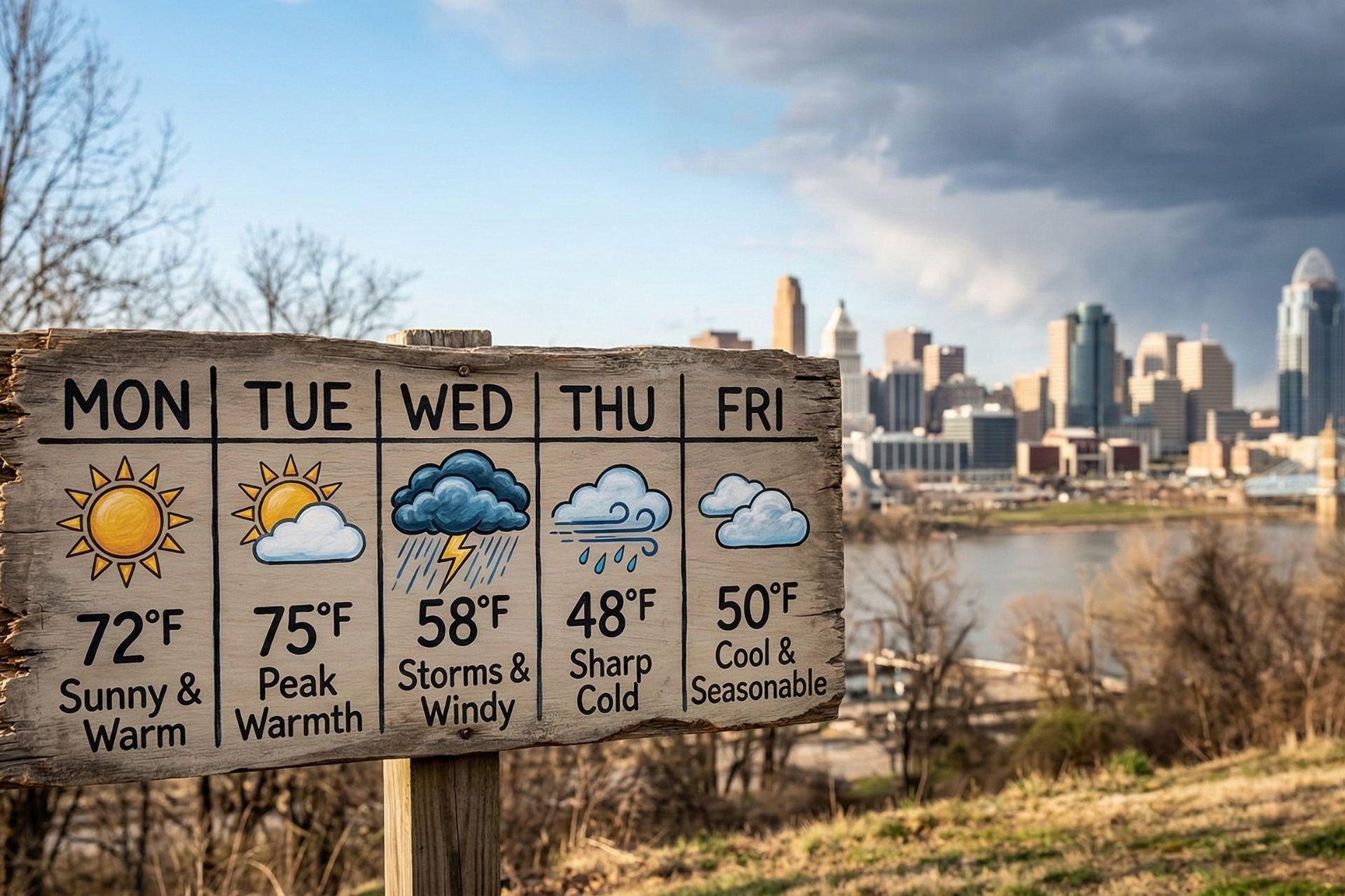
Cincinnati’s weekly weather planner shows a warm start to the week before storms arrive midweek. Temperatures could climb into the 70s Monday and Tuesday, well above normal for early March. Forecasters say a cold front will move into the Ohio Valley by Tuesday night or Wednesday, bringing rain, thunderstorms, and gusty winds. After the storm system passes, temperatures are expected to drop sharply, returning closer to seasonal averages. Meteorologists say the rapid changes reflect a typical early-spring pattern in the Midwest, when warm Gulf air briefly pushes north before cooler air returns.
The weekly weather planner for Cincinnati shows an unusually warm start to the week before storms move into the region.
A surge of warm air will give Greater Cincinnati a taste of spring before a midweek storm system changes the forecast.
Meteorologists say temperatures could climb well above normal for early March during the first half of the week. The warm conditions may push daytime highs into the 70s, creating a mild and sunny start to the week. However, a strong weather system is expected to move through the region by midweek. That system will likely bring rain, thunderstorms, and a sharp drop in temperatures.
Local forecasters say the warm conditions are part of a classic early-spring weather pattern in the Midwest. According to meteorologists reported by WLWT, the Cincinnati area will see temperatures far above seasonal averages before storms arrive later in the week. The shift will occur as warm air from the Gulf of Mexico moves northward into the Ohio Valley.
Early-week warmth may also create favorable conditions for thunderstorms once a cold front approaches the region.
Weekly weather planner shows warm start to the week
The weekly weather planner indicates that Monday and Tuesday will likely bring the warmest temperatures of the week. Sunshine and southerly winds will push temperatures close to spring-like levels.
Forecasters expect highs in the upper 60s to mid-70s during the early part of the week. These readings are significantly warmer than Cincinnati’s normal early-March average highs in the upper 40s. According to the National Weather Service, the region’s average high temperature in early March typically ranges between 45 and 50 degrees.
This warm air will arrive as strong southerly winds carry moisture and heat into the Ohio Valley. As a result, residents across the Cincinnati metro area may experience mild afternoons and comfortable evenings.
Weather experts say these conditions may briefly create a “false spring,” a term commonly used when early warm weather appears before winter-like temperatures return.
The warm conditions could also increase outdoor activity across the region as residents take advantage of the pleasant weather.
Key expectations for early in the week include:
- High temperatures near 70 degrees or warmer
- Mostly sunny skies
- Mild overnight temperatures in the 50s
- Light to moderate southerly winds
Despite the pleasant start, forecasters warn that this weather pattern will not last long.
Weekly weather planner predicts midweek storms
The weekly weather planner indicates that a powerful storm system will move into the Cincinnati region by Tuesday night or Wednesday.
According to reporting by WLWT meteorologists, rain chances will increase rapidly as a cold front approaches the Ohio Valley. That front will likely trigger widespread showers and possible thunderstorms.
Meteorologists say the combination of warm air and incoming cold air can create unstable atmospheric conditions. This setup often leads to thunderstorms, gusty winds, and heavy rain.
While severe weather is not guaranteed, forecasters say storms could produce brief downpours and strong wind gusts in some areas.
Rain chances could remain high throughout Wednesday as the weather system slowly moves across the region.
Residents should monitor local forecasts for updates, especially if outdoor activities or travel plans are scheduled.
Weather experts say midweek storms could bring:
- Periods of heavy rain
- Isolated thunderstorms
- Gusty winds
- Reduced visibility during downpours
The storm system may also cause temporary travel delays during peak commute hours.
City officials often encourage drivers to slow down during heavy rain and watch for ponding water on roadways.
Temperature swings highlight classic March weather
Large temperature swings are common during early spring in the Ohio Valley. Meteorologists say Cincinnati frequently experiences rapid changes between warm and cold air masses in March.
After the midweek storms pass, colder air is expected to move into the region. Forecasters say temperatures could fall dramatically within 24 hours of the cold front.
High temperatures may drop from the 70s early in the week to the upper 40s or low 50s later in the week. Overnight temperatures may also fall into the 30s by Thursday or Friday.
These rapid changes are typical of seasonal transitions between winter and spring.
Weather experts say the Ohio Valley often becomes a battleground between warm southern air and cooler northern air during March. This clash of air masses can produce frequent storm systems and changing forecasts.
Residents may notice several weather changes throughout the week, including:
- Warm spring-like afternoons early in the week
- Rain and thunderstorms during the middle of the week
- Cooler temperatures and breezy conditions later in the week
Although the temperature drop may feel dramatic, forecasters say the cooler air will simply return the region to more normal seasonal conditions.
What Cincinnati residents should expect this week
Cincinnati residents can expect a mix of spring-like warmth and stormy weather during the upcoming week.
Meteorologists recommend enjoying outdoor activities early in the week before the storm system arrives. However, they also advise residents to stay aware of updated forecasts.
Weather patterns during March often change quickly. Storm timing and rainfall totals may shift as the system approaches.
Local officials also remind residents to prepare for potential travel slowdowns during rainy conditions.
Drivers should allow extra time for commutes and watch for slippery roads when storms arrive.
Why spring weather patterns change so quickly
Meteorologists say the rapid changes seen in this weekly weather planner reflect the broader transition from winter to spring.
During March, jet stream patterns shift across the United States. This shift allows warmer air to push northward more frequently. At the same time, colder air masses from Canada can still move south into the Midwest.
When these air masses collide, storm systems often develop.
These systems frequently bring rain, thunderstorms, and temperature swings to the Ohio Valley.
Cincinnati’s location along the Ohio River also contributes to shifting weather patterns. Moisture from the Gulf of Mexico can travel north along the river valley, fueling stronger storm systems.
Because of these factors, Cincinnati often experiences some of the most unpredictable weather of the year during early spring.
Despite the storm chances later in the week, the warm start to the forecast offers a reminder that spring is approaching.
Residents across the region may soon see more consistent mild weather as the season progresses into April.
FAQs
What does the weekly weather planner say about Cincinnati’s weather this week?
The weekly weather planner shows a warm start to the week across Cincinnati before storms arrive midweek. Temperatures may reach the 70s early in the week, followed by rain, thunderstorms, and cooler conditions later.
When will storms likely arrive in Cincinnati this week?
Storms are expected to move into the Cincinnati area Tuesday night into Wednesday. Forecasters say a cold front will bring widespread rain and possible thunderstorms as it passes through the Ohio Valley.
How warm will temperatures get before the storms arrive?
Temperatures could climb into the upper 60s or mid-70s early in the week. This is significantly warmer than typical early-March temperatures in the Cincinnati region.
Will temperatures drop after the storm system passes?
Yes, temperatures are expected to drop noticeably after the cold front moves through the area. Highs may fall back into the 40s or low 50s later in the week, which is closer to seasonal averages.
Why is Cincinnati experiencing such large weather changes this week?
Rapid weather changes are common in early spring across the Ohio Valley. Warm air from the Gulf of Mexico often clashes with colder northern air, creating storms and quick temperature swings.
